Trying to make sense of Hampton Bays from a distance can feel confusing. Is your best fit near the canal and town, along the bay with a dock, or out on the barrier beach by the ocean? You want the right lifestyle without surprises around flood risk, commuting, or permits.
This guide breaks Hampton Bays into three clear bands you can see on a map, then walks you through the tradeoffs, due diligence, and a simple workflow to build a short list. By the end, you will know where to focus and what to verify before you write an offer. Let’s dive in.
Hampton Bays at a glance
Hampton Bays is a hamlet in the Town of Southampton with both mainland neighborhoods and a barrier beach across the Ponquogue Bridge that faces the Atlantic. You can think of the area in three east to west bands:
- Canal-side and inland near Montauk Highway and the LIRR station.
- Bayside along Shinnecock Bay, Tiana Bay, and connected inlets.
- Ocean and barrier beach beyond the bridge with direct Atlantic exposure.
A strong year-round community lives here, and summer brings a seasonal surge. That affects traffic, parking, beach access, and rental demand. Visualizing these bands helps you match homes to commute, boating, or beach priorities.
Canal-side and inland: convenience first
Canal-side and inland neighborhoods branch off Montauk Highway and include the commercial core and the Hampton Bays LIRR station on the Montauk Branch. Some streets connect to tidal canals and creeks that lead toward the bay.
- Lifestyle cues: Short drives to grocers, banks, and services. Better for regular commuting and everyday errands. Select canal homes offer private docks with motorboat access via local waterways.
- Property types: Capes, ranches, split-levels, smaller single-family homes, duplexes, and a limited number of condominiums. You will see a mix of renovated houses and seasonal cottages.
- Tradeoffs: Convenience is high and open-ocean surge is lower than the barrier beach, but some canal-front properties sit in FEMA flood zones and can experience tidal flooding. LIRR service exists, yet schedules on the Montauk Branch are less frequent than major commuter lines, so confirm actual train times.
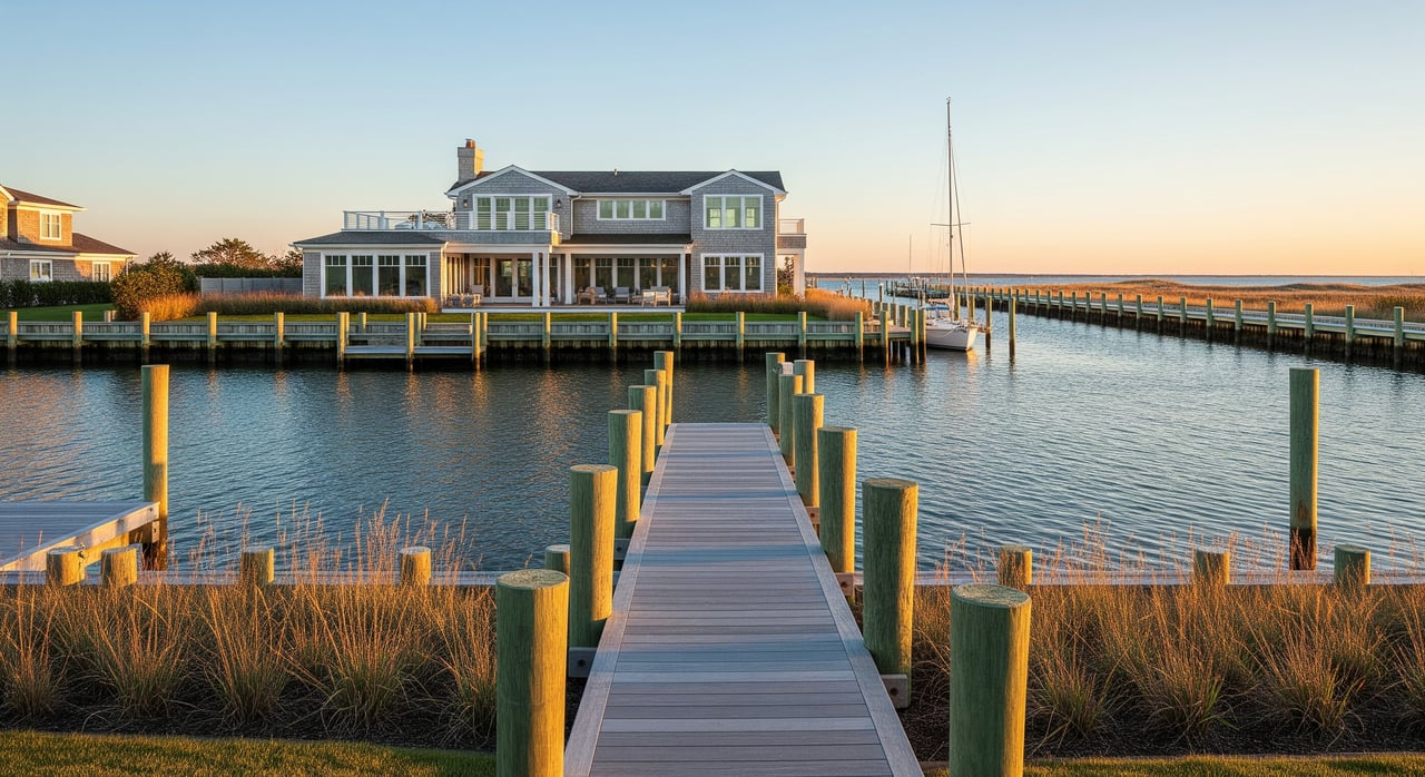
Bayside: boating and protected waters
Bayside properties front Shinnecock Bay, Tiana Bay, and protected inlets. This is the heart of the local boating culture.
- Lifestyle cues: Marina corridors, clamming and shellfishing in season, and easy access for kayaks and paddleboards. Many homes include private docks or sit near marinas that connect to the ocean through nearby inlets.
- Property types: Waterfront estates, raised bay cottages, renovated seasonal homes, and lots with private slips.
- Tradeoffs: You pay a premium for water views and dockage. Many bayside parcels fall within FEMA flood zones and may require elevation, pilings, or flood insurance. Rules and conditions for water quality, shellfish harvesting, and boating come from state and town authorities, so plan to verify before you buy.
Ocean and barrier beach: surf and exposure
Across the Ponquogue Bridge, the barrier beach delivers oceanfront dunes, surf fishing, and immediate beach access.
- Lifestyle cues: You are steps from the Atlantic with a unique dune environment and wide beaches.
- Property types: Elevated homes on pilings, beach cottages, and newer construction to current coastal codes. Many homes are seasonal or vacation focused.
- Tradeoffs: Oceanfront views command the highest prices, and exposure to storms, erosion, and FEMA V-zone rules is also highest. Flood insurance and potential rebuild costs are key items to evaluate. Commercial services are limited on the beach, so plan to drive back to the mainland for daily needs.
Commute and transport basics
- LIRR: Hampton Bays is on the Montauk Branch. Trains run, but express options are limited compared to lines closer to New York City. Check current schedules to verify your commute window.
- Roads: Montauk Highway is the main east to west corridor. Expect heavier congestion on summer weekends.
- Beach parking: Public lots and county or town parks have seasonal rules and fees. Barrier beach parking can be tight in peak months.
Boating access and marinas
- Access types: On-lot private docks, slips at local marinas, and public boat launches. Bayfront properties often have the easiest docking with protected water.
- Inlet navigation: To reach the ocean, boaters use nearby inlets. Conditions change with tides and currents, so rely on local guidance and marina services.
- Shellfishing: Activities and closures shift by season and water quality. New York State environmental authorities publish the rules and maps you should review before harvesting.
Flood risk and insurance essentials
- Flood zones: Large portions of bayside and the barrier beach appear in FEMA Special Flood Hazard Areas such as AE and VE. Canal-front parcels often sit in AE or A zones.
- Insurance: Lenders typically require flood insurance for mapped zones. Premiums depend on elevation, construction type, and local community factors. Private flood policies are an option in addition to federal programs.
- Climate and erosion: Sea-level rise and coastal erosion affect the shoreline, with barrier beach parcels being the most exposed. A smart plan is to get an elevation certificate, review the latest FEMA Flood Insurance Rate Maps, and confirm base flood elevation requirements with the local building department.
Utilities, septic, and sewer checks
- Septic vs sewer: Much of eastern Long Island relies on on-site septic systems. Some subareas may have sewer plans or limited connection options.
- Due diligence: Confirm system capacity, maintenance records, and any constraints on additions tied to septic size. If a sewer expansion is planned, ask for timing and requirements.
Zoning, coastal rules, and rentals
- Town rules: Zoning maps, coastal setbacks, and shoreline protection rules control additions, rebuilds, and new construction in sensitive zones. Expect additional review for waterfront improvements.
- State and federal: New York State environmental agencies regulate tidal wetlands and coastal consistency, and the Army Corps may be involved with navigational work.
- Short-term rentals: The Town of Southampton has rules governing short-term rentals. If you plan to rent seasonally, verify permits, limits, and enforcement before you buy.
Schools, services, and health care
- Schools: Hampton Bays Union Free School District serves the hamlet. If school programs or attendance zones matter to you, request the latest district information.
- Health care: Stony Brook Southampton Hospital and regional urgent care centers in Southampton and Westhampton serve local needs.
- Commerce: Groceries, pharmacies, and banks concentrate along Montauk Highway. Specialty services are also available in nearby Southampton and Bridgehampton.
Seasonality and market patterns
- Pricing: Values vary by water exposure, proximity to the LIRR, and property condition. Waterfront and oceanfront homes command a premium. Inland and canal-area properties are often more attainable.
- Rentals: Summer rental demand is strong. Local rules, HOA covenants, and permits may limit short-term activity, so verify the specifics early in your search.
Map-driven search: a simple workflow
- Step 1 — Set lifestyle priorities: Rank commute, boating, and beach in order of importance.
- Step 2 — Draw your map filters:
- Commute: Start with a 5 to 10 minute radius around the Hampton Bays LIRR station.
- Boating: Select bayfront parcels, marinas, and canal networks with direct routes to protected water.
- Beach: Include the barrier beach and mainland homes within a short walk or drive to public access near the Ponquogue Bridge area.
- Step 3 — Overlay risk and utilities: Add FEMA flood zones, shoreline erosion areas, and any sewer district maps.
- Step 4 — Filter by property details: Elevation on pilings, dock presence, lot size, age, and renovation level.
- Step 5 — Field test: Visit at peak times to check access, parking, noise, neighbor density, cell coverage, and any visible flood markers.
Short-list checklist for each property
- Location: Which band is it in (inland, bay, ocean)? Distance to LIRR, Montauk Highway, marina, and public beach access.
- Flood and elevation: FEMA flood zone, elevation certificate on file, and basement status.
- Utilities: Septic or sewer, age and condition of the system, and the water and electric providers.
- Zoning and use: Single-family zoning, rental restrictions, and any existing permits.
- Insurance: Current homeowners and flood insurance costs and carrier type.
- Boat access: Dock ownership, water depth, and any tidal constraints.
- Condition and scope: Immediate repairs, long-term upgrades, and coastal setback limits that could affect future work.
What fits your lifestyle
- Choose canal-side and inland if daily convenience and LIRR access matter most, and you want a mix of home types at more varied price points.
- Choose bayside if boating, protected water access, and the marina scene are central to your plans.
- Choose the barrier beach if oceanfront living is your priority and you are comfortable planning for higher insurance, coastal rules, and storm exposure.
Next steps
If you want a clear, confidence-building path, start with a map session and the checklist above. A focused tour that compares one or two homes in each band will sharpen your preferences in a single afternoon. When you are ready, our team can help you verify FEMA zones, elevation data, permitting paths, and rental rules so you can move forward without guesswork.
Ready to narrow your search or prepare a property for the market? Contact The Hampton Edge Team for a tailored plan and Get Your Free Home Valuation.
FAQs
What are the main areas in Hampton Bays for homebuyers?
- Hampton Bays divides into canal-side and inland near Montauk Highway, bayside along Shinnecock and Tiana bays, and the ocean-side barrier beach beyond the Ponquogue Bridge.
How does flood risk differ by canal, bay, and ocean locations?
- Canal and bay homes often sit in FEMA AE or A zones, while ocean-side parcels commonly face VE zones with higher exposure, which affects elevation needs and insurance.
Is LIRR service practical from Hampton Bays for commuting?
- The Montauk Branch serves Hampton Bays, but trains run less frequently than major commuter lines, so you should confirm schedule times that match your routine.
What should boaters verify before buying in Hampton Bays?
- Confirm dock rights or marina slip options, water depth and tidal constraints, and local navigation through nearby inlets, plus any shellfishing rules you plan to follow.
How do rentals work in Hampton Bays and the Town of Southampton?
- Short-term rentals are regulated by the town; you should verify permit requirements, allowed durations, and enforcement policies before planning seasonal income.
What are the key due diligence steps for oceanfront properties?
- Obtain an elevation certificate, review FEMA flood maps and base flood elevations, confirm coastal setbacks, and get insurance quotes that reflect VE-zone exposure.
Where are most services located for daily needs in Hampton Bays?
- Most grocers, pharmacies, banks, and everyday services cluster along Montauk Highway on the mainland, with limited commercial options on the barrier beach.